

Anybody have any idea how to get a mid-20th century road atlas of Germany or Italy or both on line?
I would really like to have a Michelin or Google-earth style map of them. I think other developers would like to have 1940s or even 1950s detail maps of France, Belgium, Balkans, Baltic states, Byelorussia, etc etc. The published battle maps only show a couple of major towns and some important crossroads where an engagement may have happened.
But they don't serve the purpose for recreating the available routes, population centers, etc of WWII.
The maps we can find now are like trying to use a recent map of Florida to explain the ground situation in 1949 before they eliminated free-range cattle farming...
conboy
Here's one for Italy that I just discovered after I posted.
http://www.custermen.com/Maps/ArmyMaps.htm
I guess I didn't look hard enough...
https://legacy.lib.utexas.edu/maps/ams/italy_250k/
1940s Atlas
Moderators: Order of Battle Moderators, The Artistocrats
-
KarisFraMauro
- Master Sergeant - U-boat

- Posts: 507
- Joined: Sat Jun 08, 2019 10:49 pm
Re: 1940s Atlas
Post by KarisFraMauro »
I wonder if any millitary organizations / veterans associations might help? This almost sounds like a historical crowdscience project, having volunteers scan old documents into online databases. Hmm. Maybe museums...


Re: 1940s Atlas
If you're looking for detailed maps of the Central European or Western USSR regions, I recommend the Polish collection of maps. I usually use detailed topographic maps from the WIG Institute or simplified aerial maps. Highly recommended.
Here is a compilation of all the maps and indexes:
http://igrek.amzp.pl/
And here, for example, is a detailed map of Poland and its surroundings:
http://igrek.amzp.pl/mapindex.php?cat=wig100
Here is a compilation of all the maps and indexes:
http://igrek.amzp.pl/
And here, for example, is a detailed map of Poland and its surroundings:
http://igrek.amzp.pl/mapindex.php?cat=wig100
-
bondjamesbond
- Lieutenant-General - Do 217E

- Posts: 3001
- Joined: Mon Jun 27, 2022 10:10 pm
Re: 1940s Atlas
Post by bondjamesbond »
Zbrozlo wrote: Fri Sep 15, 2023 6:14 am If you're looking for detailed maps of the Central European or Western USSR regions, I recommend the Polish collection of maps. I usually use detailed topographic maps from the WIG Institute or simplified aerial maps. Highly recommended.
Here is a compilation of all the maps and indexes:
http://igrek.amzp.pl/
And here, for example, is a detailed map of Poland and its surroundings:
http://igrek.amzp.pl/mapindex.php?cat=wig100
https://atlas1940.narod.ru/main.htm
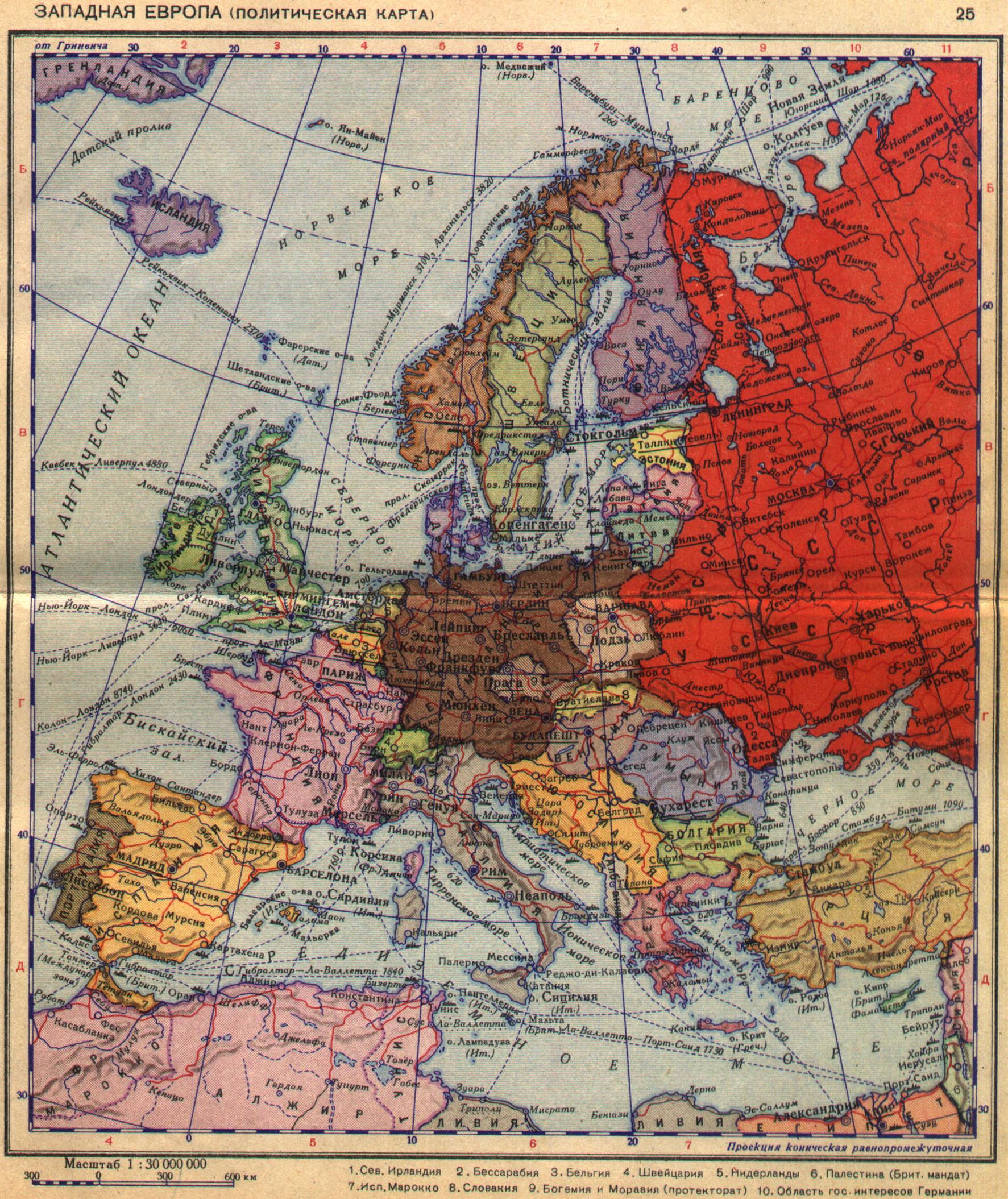
http://atlases.narod.ru/
https://mynickname.com/id73473

Return to “Order of Battle : World War II - Scenario Design”
Jump to
- Announcements & General Discussion
- ↳ News & Announcements
- ↳ General Discussion
- ↳ Game Ideas
- ↳ Archive
- ↳ Slitherine/Matrix Press Event 2012 - The Home of Wargamers
- ↳ Blogs
- ↳ Deadliest Warrior on Spike TV
- ↳ Military Art
- ↳ Shenandoah General Discussion Forum
- ↳ Shenandoah Studio Website
- ↳ Gettysburg: The Tide Turns
- ↳ Gettysburg: The Tide Turns - Technical Support
- ↳ Gettysburg: The Tide Turns - After Action Reports (AAR)
- ↳ Battle of the Bulge
- ↳ Battle of the Bulge: Tech Support
- ↳ Drive On Moscow
- ↳ Drive on Moscow iPad
- ↳ Desert Fox: The Battle of El Alamein
- Regional
- ↳ Español
- Coming Soon
- ↳ Bolt Action
- ↳ Battleplan
- ↳ Stormbinders
- ↳ Platoon Commander
- ↳ Space Station Designer
- ↳ Space Station Designer - Discord Server
- ↳ Ancient Arenas: Chariots
- ↳ Radio Commander: Pacific '41
- Latest Releases
- ↳ Starship Troopers - Terran Command
- ↳ Panzer Corps 2
- ↳ Join the Discord server
- ↳ Panzer Corps 2: Tech Support
- ↳ Panzer Corps 2 Scenario Design
- ↳ Panzer Corps 2: Multiplayer & Tournaments
- ↳ Panzer Corps 2 AARs
- ↳ ICBM: Escalation
- ↳ ICBM: Escalation Tech Support
- ↳ ICBM: Escalation - Discord Server
- ↳ Field of Glory: Kingdoms
- ↳ Field of Glory: Kingdoms - Modding and Scenarios
- ↳ Field of Glory: Kingdoms - After Action Reports
- ↳ Headquarters: Cold War
- ↳ Terminator: Dark Fate – Defiance
- ↳ Terminator: Dark Fate Defiance Tech Support
- ↳ Broken Arrow
- ↳ Headquarters World War II
- ↳ Scramble: Battle of Britain
- ↳ Stargate: Timekeepers
- ↳ Stargate: Timekeepers - Tech Support
- ↳ Master of Magic
- ↳ Field of Glory II
- ↳ Field of Glory II: Tech Support
- ↳ Field of Glory II: Scenario Design
- ↳ Field of Glory II: Modding
- ↳ Field of Glory II: After Action Reports
- ↳ Field of Glory II: Tournaments & Leagues
- ↳ Field of Glory II Digital League
- ↳ Knock-out Tournament
- ↳ Field of Glory II: The Divisional Championships
- ↳ FOG II World Team Championship
- ↳ Archive
- ↳ Field of Glory II: Frequently Asked Questions
- ↳ The FOGII Beta Archives
- ↳ Field of Glory II 1.5.15 Public Beta
- ↳ Field of Glory II 1.5.20 Public Beta
- ↳ Field of Glory II 1.5.22 Public Beta
- ↳ Field of Glory II - 1.5.24 Open Beta
- ↳ Field of Glory II - 1.5.26 Open Beta
- ↳ Field of Glory II - 1.5.27 Open Beta
- ↳ Field of Glory II - 1.5.29 Open Beta
- ↳ Field of Glory II - 1.5.31 Open Beta
- ↳ Field of Glory II - Open Beta 1.5.33
- ↳ Field of Glory II - Open Beta 1.5.37
- ↳ Field of Glory II Open Beta v.1.5.39
- ↳ Warhammer 40,000: Battlesector
- ↳ Planetary Supremacy
- ↳ Warhammer 40,000: Gladius - Relics of War
- ↳ Warhammer 40,000: Gladius - Relics of War: Tech Support
- ↳ Warhammer 40,000: Gladius - Relics of War: Modding
- ↳ Warhammer 40,000: Gladius - Relics of War: Suggestions
- ↳ Master of Magic Classic
- ↳ Master of Magic: Tech Support
- ↳ Caster of Magic
- ↳ Field of Glory II: Medieval
- ↳ Field of Glory II: Medieval Tech Support
- ↳ Field of Glory II: Medieval - Scenario Design
- ↳ Field of Glory II: Medieval - Modding
- ↳ Field of Glory II: Medieval - After Action Reports
- ↳ Field of Glory II: Medieval - Tournaments & Leagues
- ↳ Field of Glory II: Medieval - Frequently Asked Questions
- ↳ Field of Glory II: Medieval Beta Archives
- ↳ Field of Glory II: Medieval - Open Beta v.1.5.7
- ↳ Field of Glory II: Medieval - Open Beta
- ↳ Order of Battle Series
- ↳ Order of Battle : World War II - Tech Support
- ↳ Order of Battle Bug Submissions
- ↳ Order of Battle : World War II - AAR
- ↳ Order of Battle : World War II - Scenario Design
- ↳ Order of Battle : World War II - Multiplayer
- ↳ Multiplayer Beta
- ↳ Fantasy General II - Invasion
- ↳ Fantasy General II - Invasion: Tech Support
- ↳ Content Editor
- ↳ Fantasy General II - Beta Archive
- ↳ ICBM
- ↳ ICBM:Tech Support
- ↳ ICBM:Features you would like to see
- ↳ Stirring Abyss
- ↳ Battlestar Galactica Deadlock
- ↳ Battlestar Galactica Deadlock: Tech Support
- ↳ Shadow Empire
- ↳ Field of Glory: Empires
- ↳ Dev Diaries
- ↳ Field of Glory: Empires - Tech Support
- ↳ MOD
- ↳ AAR
- ↳ Field of Glory: Empires Beta Archive
- ↳ FOG Empires Open Beta v.1.3.5
- ↳ Diplomacy Open Beta
- ↳ Command: Modern Operations
- ↳ Astra Exodus
- ↳ Tech Support
- ↳ Afghanistan '11
- ↳ Afghanistan '11: Tech Support
- ↳ Strategic Command WWI
- ↳ Armored Brigade
- ↳ WarPlan
- ↳ Close Combat: The Bloody First
- ↳ Empires Apart
- ↳ Empires Apart PBEM
- ↳ Strategic Command WWII: World at War
- ↳ Aggressors: Ancient Rome
- ↳ Aggressors: Tech Support
- ↳ Aggressors Modding
- ↳ Aggressors AARs
- ↳ March to Glory
- ↳ Tech Support: March to Glory
- ↳ Warhammer 40,000: Sanctus Reach
- ↳ Sanctus Reach After Action Reports (AAR)
- ↳ Sanctus Reach Mods and Scenario Design
- ↳ Sanctus Reach Opponents Wanted
- ↳ Sanctus Reach Tech Support
- ↳ The Operational Art of War IV
- ↳ Check Your 6!
- ↳ Check Your 6!: Tech Support
- ↳ Polaris Sector
- ↳ Tech Support
- ↳ Modders Corner
- ↳ Mare Nostrvm
- ↳ Gettysburg: The Tide Turns
- ↳ Warhammer® 40,000® Armageddon™
- ↳ Warhammer AAR
- ↳ Tech Support
- ↳ Mods and Scenario Design
- ↳ Warhammer Open Beta
- ↳ Carrier Deck
- ↳ Carrier Deck: Tech Support
- ↳ Panzer Corps
- ↳ Panzer Corps Open Beta
- ↳ Panzer Corps Mac Open Beta
- ↳ Panzer Corps : Tech Support
- ↳ Panzer Corps : AAR's
- ↳ Panzer Corps : Scenario Design
- ↳ Panzer Corps 2
- ↳ Close Combat Series
- ↳ Close Combat : Tech Support
- ↳ Close Combat - Gateway to Caen
- ↳ Close Combat - Gateway to Caen : Tech Support
- ↳ Close Combat - Gateway to Caen - Match Making Forum
- ↳ Close Combat - Panthers in the Fog
- ↳ Close Combat - Match Making Forum
- ↳ Close Combat - Panthers in the Fog: Tech Support
- ↳ RuneQuest: Warlords
- ↳ RuneQuest: Warlords - Tech Support
- ↳ Nightmare Frontier
- Classic Games A-Z
- ↳ Airstrike Eagles of WWII
- ↳ Airstrike : Tech Support
- ↳ Alea Jacta Est Series
- ↳ Alea Jacta Est Series : Tech Support
- ↳ Battle Academy
- ↳ Battle Academy : Open Beta
- ↳ Battle Academy : Tech Support
- ↳ Battle Academy : Modders Corner
- ↳ Battle of the Scheldt Beta
- ↳ Battle Academy : Scenario Design
- ↳ Battle Academy : Tournaments & Leagues
- ↳ Battle Academy 2 – Eastern Front
- ↳ Tech Support
- ↳ Battle Academy 2: Modders Corner
- ↳ Battle Academy 2: Scenario Design
- ↳ Battle Academy 2: Tournaments & Leagues
- ↳ Battle Academy 2: AAR
- ↳ Battle of the Bulge
- ↳ Buzz Aldrin's Space Program Manager
- ↳ Buzz Aldrin's Space Program Manager : Tech Support
- ↳ Buzz Aldrin's Space Program Manager : Early Access Beta Forum
- ↳ Campaign Series: Middle East 1948 - 1985
- ↳ Chariots of War
- ↳ Civil War II
- ↳ Civil War II : Tech Support
- ↳ Civil War II : AAR's
- ↳ Command - Modern Air/Naval Operations
- ↳ Commander - Napoleon at War
- ↳ Commander - Napoleon at War : Tech Support
- ↳ Commander - The Great War
- ↳ Commander - The Great War: Tech Support
- ↳ Commander The Great War AAR's
- ↳ Commander the Great War : Mods & Scenario Design
- ↳ Commander the Great War : Opponent Finder
- ↳ Conflict of Heroes
- ↳ Conflict of Heroes : Tech Support
- ↳ Conflict of Heroes : AAR's
- ↳ Match making forum
- ↳ Conquest!
- ↳ Conquest! : Tech Support
- ↳ Decisive Campaigns Series
- ↳ Distant Worlds Series
- ↳ Drive on Moscow
- ↳ Drums of War
- ↳ Drums of War : Tech Support
- ↳ Egypt - Engineering an Empire
- ↳ Egypt - Engineering an Empire : Tech Support
- ↳ España: 1936
- ↳ Fantasy Kommander – Eukarion Wars
- ↳ Fantasy Kommander – Eukarion Wars : Tech Support
- ↳ Field of Glory Digital
- ↳ Field of Glory : Tech Support
- ↳ Field of Glory : Scenario Design
- ↳ Field of Glory : Leagues & Tournaments & Seeking Opponents
- ↳ The FOG Digital League
- ↳ The Slitherine Trophy
- ↳ Field of Glory: League of Extraordinary Gentleman
- ↳ Field of Glory : AAR's
- ↳ FoG PC Beta
- ↳ Old Beta Test
- ↳ Bug Reports
- ↳ Field of Glory Campaigns
- ↳ Flashpoint campaigns: Red Storm
- ↳ Frontline Series
- ↳ Frontline Road to Moscow
- ↳ Frontline: Road to Moscow Tech Support
- ↳ Frontline: Road to Moscow Beta
- ↳ PC Beta
- ↳ Android Beta
- ↳ iOS Beta
- ↳ Frontline: The Longest Day
- ↳ Tech Support
- ↳ Gary Grigsby's War in the East
- ↳ Gary Grigsby's War in the East : Tech Support
- ↳ Gary Grigsby’s War in the West
- ↳ Germany at War: Barbarossa 1941
- ↳ Germany at War: Barbarossa 1941 : Tech Support
- ↳ Germany at War: Barbarossa 1941 : AAR's
- ↳ Hannibal: Rome and Carthage
- ↳ Hannibal: Rome and Carthage - Tech Support
- ↳ Hell
- ↳ Tech Support
- ↳ Heroes of Normandie
- ↳ Tech Support
- ↳ Mods and Scenario Design
- ↳ HISTORY™ Great Battles Medieval
- ↳ HISTORY™ Great Battles Medieval : Tech Support
- ↳ HISTORY™ Great Battles Medieval : Modding
- ↳ HISTORY®: Legends of War
- ↳ Tech Support
- ↳ Last Days of Old Earth
- ↳ Tech Support
- ↳ Legion & Legion Gold
- ↳ Legion and Legion Gold: Tech Support
- ↳ Legion Arena & CoM
- ↳ Legions of Steel
- ↳ Tech Support
- ↳ Lock 'n Load: Heroes of Stalingrad
- ↳ Lock 'n Load: Heroes of Stalingrad - Tech Support
- ↳ Magnifico - Da Vinci’s Art of War
- ↳ Tech Support
- ↳ MILITARY HISTORY™ Commander - Europe at War : General Discussion
- ↳ Commander - Europe at War : Tech Support
- ↳ Commander - Europe at War : Modders Corner
- ↳ Commander Europe at War : AAR's
- ↳ Commander Europe at War : Opponent Finder
- ↳ Commander Europe at War : GS Open Beta
- ↳ Napoleon's Campaigns
- ↳ Pandora - First Contact
- ↳ Pandora : Public Beta
- ↳ Pandora : Tech Support
- ↳ Pandora : Modders Corner
- ↳ Pike & Shot
- ↳ Tech Support
- ↳ Scenario Design
- ↳ After Action Reports
- ↳ Modders Corner
- ↳ Opponents Wanted
- ↳ Pike & Shot : Tournaments & Leagues
- ↳ Piercing Fortress Europa
- ↳ Pride of Nations
- ↳ QVADRIGA
- ↳ QVADRIGA : Tech Support
- ↳ Ravenmark: Scourge of Estellion
- ↳ Tech Support
- ↳ Revolution Under Siege Gold
- ↳ Rise of Prussia Gold
- ↳ Sengoku Jidai: Shadow of the Shogun
- ↳ Tech Support
- ↳ Scenario Design
- ↳ Modders Corner
- ↳ After Action Reports
- ↳ Opponents Wanted
- ↳ Sengoku Jidai: Tournaments & Leagues
- ↳ Scourge of War Gettysburg
- ↳ Scourge of War Series : Tech Support
- ↳ Scourge of War: Waterloo
- ↳ Sovereignty
- ↳ Sovereignty: Tech Support
- ↳ Sovereignty: AAR
- ↳ Sovereignty: Modders Corner
- ↳ Spartan & Gates of Troy
- ↳ Star Hammer
- ↳ Star Hammer: Tech Support
- ↳ Star Hammer: Scenario Design
- ↳ Strategic Command: WWII War in Europe
- ↳ Strategic War in Europe
- ↳ Tech Support
- ↳ Team Assault
- ↳ Match making forum
- ↳ Team Assault : Tech Support
- ↳ THE HISTORY CHANNEL™ Great Battles of Rome
- ↳ THE HISTORY CHANNEL Great Battles of Rome : Tech Support
- ↳ Thirty Years' War
- ↳ Tigers on the Hunt
- ↳ Time of Fury
- ↳ Time of Fury AAR's
- ↳ Time of Fury : Tech Support
- ↳ Time of Fury : Scenario Design & Modding
- ↳ Time of Fury : Open Beta
- ↳ To End All Wars
- ↳ Tech Support
- ↳ Unity of Command
- ↳ Victory and Glory
- ↳ Vietnam '65
- ↳ Vietnam '65 - Tech Support
- ↳ Wars of Napoleon
- ↳ Battleplan Closed Beta
- Online Ordering & Support
- ↳ Online Ordering & Support
- ↳ Site Feedback
- ↳ Invitation system support
- Tabletop Wargaming
- ↳ Field of Glory : Ancient & Medieval Era 3000 BC-1500 AD : General Discussion
- ↳ Rules Questions
- ↳ Scenarios, AAR's, Lists, Modelling and more
- ↳ Historical Scenarios
- ↳ Field of Glory AAR's
- ↳ Army Design
- ↳ Modelling
- ↳ Player Designed Lists
- ↳ Tournaments & Opponents
- ↳ Tournaments
- ↳ Opponent Finder
- ↳ Foreign Language Forums
- ↳ French Speaking Forum
- ↳ Spanish Speaking Forum
- ↳ Italian Speaking Forum
- ↳ German Speaking Forum
- ↳ Tech Support
- ↳ Field of Glory 3.0 Beta
- ↳ Marketplace
- ↳ Field of Glory : Napoleonic Era 1792-1815 : General Discussion
- ↳ Rules Questions
- ↳ Campaigns
- ↳ Scenarios, AAR's, Lists, Modelling and more
- ↳ Historical Scenarios, Maps, and Orders of Battle (OOB)
- ↳ FoGN After Action Reports (AAR)
- ↳ Army Design
- ↳ Player Designed Lists and Adaptions
- ↳ Modelling/Gallery/Uniforms Questions
- ↳ Tournaments, Demos & Opponents
- ↳ FoGN Community: Opponent Finder, Clubs, Blogs, etc.
- ↳ Foreign Language Forums
- ↳ French Speaking Forum
- ↳ Spanish Speaking Forum
- ↳ Italian Speaking Forum
- ↳ German Speaking Forum
- ↳ Marketplace
- ↳ Field of Glory : Renaissance Wars : General Discussion
- ↳ Historical Scenarios
- ↳ Rules Questions
- ↳ After Action Reports (AAR's)
- ↳ Tournaments
- ↳ Army Design
- ↳ Player Designed Lists
- ↳ Modelling
- ↳ Campaigns
- ↳ Opponent Finder
- ↳ FOGR Update
- ↳ Marketplace
- ↳ Field of Glory : Swords & Sorcery : General Discussion
- ↳ Marketplace
- ↳ Flashpoint campaigns: Red Storm : Tech Support
- ↳ HISTORY™ Ice Road Truckers
- ↳ HISTORY™ Great Empires: Rome
- ↳ HORRIBLE HISTORIES™ Ruthless Romans
- ↳ The Tudors
- ↳ Command - Modern Air/Naval Operations : AAR's
- ↳ Command - Modern Air/Naval Operations : Tech Support
- ↳ Tech Support
- ↳ España: 1936 : Tech Support
- ↳ Piercing Fortress Europa: Tech Support
- ↳ Tech Support
- ↳ FoGR Lists
- Archive
- ↳ Gary Grisby’s World at War iPad